Copyright 2020 - 2021 irantour.tours all right reserved
Designed by Behsazanhost
The Eastern part of Fars province
The Eastern part of Fars province
To travel east of Shiraz, the visitor should take the road that goes to Pol-e Fasa. At that point, the road forks. The left fork runs along the southern shore of Lake Maharlu and goes on to Sarvestan. Beyond Sarvestan, about the same distance as from Sarvestan to Lake Maharlu, the road branches again. The left branch goes to Fasa and Darab, while the right passes by Lake Parishan and continues to Neyriz. After Neyriz, there is a long stretch dividing the settlements of Fars from the Kerman region; the road ends in Sirjan in the Kerman province.
 |
| Sarvestan Palace The Sassanid Palace |
- Sarvestan
Now no more than a sleepy town surrounded by orchards, Sarvestan was once one of the Sasanid strongholds in southern Iran. Moreover, the town's history dates back even farther than the Sasanid era, and numerous buildings, both pre-Islamic and Islamic, bear evidence of its prominent position during the different periods. Of these, the Sasanid Palace and the Mausoleum of Sheikh Yusuf are the most important.
 |
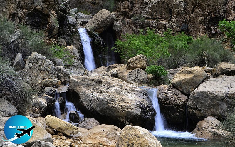
| Raghez Valley and waterfall, One of the best areas for nature & adventure tours |
- Fasa
With an area of 4,205 sq. km, the Fasa region is the fourteenth in size among the nineteen regions of Fars. More than half of its territory is occupied by mountains, of which Kharman Peak, 22 km northwest of Fasa, is the highest (3,185 m). The region enjoys a moderate climate, with cold winters and hot, dry summers. There are no permanent rivers in the area, and water is obtained from wells, qanats, and mountain springs. The natural flora includes cypresses, poplars, chestnuts, wild almonds, pistachios, and figs, as well as a variety of steppe greenery. This natural assortment was recently supplemented and enriched by the addition of artificially planted eucalyptuses, acacias, and firs. Vast areas are also covered by pastures, which are used by local stockbreeders and nomads. Among the animals seen in the region are wild goats, wolves, bears, jackals, foxes, and wildcats. There is also a rich assortment of birdlife.
The population of the Fasa region exceeds 200,000. Most of these are Persians, but there are also Lors, Turks, and Arabs. The languages spoken are the eastern dialect of Persian, as well as Lor, Turkish, and Arabic. An overwhelming majority of the people are Shiites of the Twelve Imams. Throughout history, the people of Fasa have been famous for piety and courage. Most of the population is engaged in agriculture, the main products of which include wheat, corn, cotton, and tomatoes. For a long time, Fasa was famous for its fabrics, but this craft is largely neglected today. Among the handicrafts still practiced in the region are carpet weaving and pottery.
The regional center, the town of Fasa, is one of the most ancient sites of Fars. Legend ascribes its foundation to Tahmuras the Demon-Binder, who appears to have divided the Fars region among his four sons and built for the four cities, which were named in their honor. One of these was Pasa, and the other three, Shiraz, Estakhr, and Jam. Archaeological research has proven the prehistoric origin of the town, which dates as far back as the 4th millennium B.C. Fasa's history emerges with more clarity during the Achaemenid period. Clay tablets in Elamite cuneiform, found in Persepolis by Prof. Cameron, call the town Pasah or Paa-sheia (meaning "the living place” or “the camp") and refer to it as a large and prosperous city. Historians believe that the name Pasah may have the same root as Pasargadae.
The town retained its importance throughout the Seleucid and Parthian periods and became one of the most thriving centers of the Sasanid Empire. Records of two persons of Fasa origin have survived in Sasanid books. One of them is Zoroaster of Khargan, the teacher of Mazdak, and the other is the Knight Marshal of Khosrow Anushravan's court, whose name, sad to say, has been lost to memory. During the Sasanid age, Fasa was the second most important town of the Darabgerd-khurreh (the region of Fars during the Sasanid period). Fasa still has some Sasanid relics in the ruins of Qomp-e Ateshkadeh and in the Zahak Mound.
After a strong resistance in 638, Pasa at length surrendered to the Arab troops and was called Fasa in the usual Arabic manner. In the centuries immediately follow ing the Arab conquest the town continued to prosper. It was an active textile center, and textiles produced here were much in demand in the caliph's court in Baghdad. Fasa suffered great distress during the disturbances of the Mongol and Timurid ages, but recovered remarkably under the Safavids, who rearranged the layout of the town and built many structures here. Unfortunately, during the Qajar period, epidemics and famine, aggravated by economic crisis and political unrest, undermined the prosperity of the town, which has never recovered its former glory.
 |
- Jahrom
Modern Jahrom occupies an area of about 85 sq. km, stretching in a distinctly east-west direction. Only half of the town's territory is occupied by residential quarters, while the rest is covered by groves of date palms and citrus gardens. The name of Jahrom has been variously interpreted as "the place of heat" or "the place of greenery", and both labels suit it perfectly. The town can be very hot in summer, but in winter its weather is very mild and pleasant. The maximum summer temperature is 44°C, and the minimum winter temperature is -5°C. Precipitation is rare and occurs mainly during autumn and winter. The climate is generally arid, but in some autumn and winter months, the humidity rises to 85%.
Jahrom lies in a valley, bordered on either side by rows of mountains, which are covered with almond shrubs and wild pistachio trees. The highest peak in the region is Mt. Sepidar, southeast of the town; it reaches a height of 3,170 m. Several rivers water the area, among them the Qara-Aqaj, the Simakan, and the Shur, but usually these are filled with water only during the rainy seasons.
Legend attributes the founding of Jahrom to Homay, daughter, and wife of king Bahman. Historians, however, believe that the town was founded by Artaxerxes I in the 4th century B.C. In the Shahnameh, the name of the town is mentioned repeatedly, and the earliest story recalls the events after the battle with Alexander when the defeated Dara the Younger sought refuge there. During the Sasanid period, Jahrom was part of Darabgerd-khurreh, with the capital in Darabgerd. At that time, it enjoyed a remarkable position, serving as a place of residence for Sasanid princes. The famous musician of Khosrow II's court, Barbad, so exuberantly praised by Sasanid and early Islamic writers, is said to have been born in Jahrom in 590. This renowned musical genius is reported to have composed three hundred and sixty pieces of music, and to have performed one of them on each day of the year.
In 645, because of its geographical location, Jahrom was among the first cities to be conquered by the Islamic troops. The period of turmoil and unrest that followed caused considerable deterioration in local affairs, to such an extent that we know nothing further about the town until the Safavid period. During the rule of Shah Abbas the Great, the route from Esfahan to Bandar Abbas passed through Jahrom, and this advantageous situation helped to revive the town's economy and commerce. At that time, Jahrom was also turned into a busy center for weaving, and the famous jahromi, pileless rugs produced here, were a constant object of delight for European travelers. However, in the succeeding periods, fortune once more turned its back on Jahrom. Today the town is mostly famous for its dates and limes, which have become symbols of its prosperity.
- Khafr
Khafr is the second most important town of Jahrom township. It is nestled in a narrow opening between the Simakan and Goshtasp mountain ranges, and watered by the Qara-Aqaj River. The region has a very fresh and pleasant climate with mild winters, and it is cooler in summer than in the surrounding areas. Locals are mainly engaged in horticulture, and all kinds of fruit, including sweet and sour oranges, tangerines, lemons, citrons, and dates are successfully cultivated. Khafr is among the oldest towns in the region, and two of its important historical monuments, Jamasp's Tomb and the Khalifeh Mausoleum, have survived to the present.
 |
- Neyriz
The terrain of the Neyriz region is composed mostly of ridges that are prolongations of the Zagros Mountains; the ridges run northwest-southeast and are intersected by plains. The region borders on the largest of the permanent lakes of the Fars province, Lake Bakhtegan, and Lake Tashk. The territory around Lake Bakhtegan has revealed many prehistoric sites. As a matter of fact, most of the settlements were once on the shores of Lake Bakhtegan, but because of the lake's shrinkage, they are now some distance to the southeast. The central town of the region, Neyriz, is located about 220 km east of Shiraz and is a place of great antiquity. During the Achaemenid period, Neyriz was one of the country's main armories, according to the testimony of the Elamite clay tablets found in Persepolis, and in which the name of Neyriz is first mentioned. It seems possible, however, that the original town was located southeast of the modern city, which changed its location about the Sasanid period. The city's Congregational Mosque was probably a Zoroastrian fire temple before being turned into a mosque. After such a glorious pre-Islamic history, the town lost its good fortune upon the advent of Islam. During World War I, Neyriz was occupied by the English troops led by Major Sykes. The ruins of the fort, built by the Englishmen still survive on the outskirts of the town.
Most of the local population is engaged in agriculture, the main products of which are rye, cotton, sesame, and most importantly, wheat. Poultry farming and beekeeping are also well-developed. Some of the most important stone quarries of Iran are located in the vicinity of Neyriz. The region is covered with more than 145,000 hectares of brushwood, which consists of mountain almonds, wild barberries, wild figs, and wild pistachio trees. These shrubs constitute an important wildlife habitat, and several natural protected zones have been created here to preserve the local flora and fauna.
 |
- Darab
Located about 280 km southeast of Shiraz, Darab is one of the largest and oldest cities in Fars. It lies in the Rudbar Valley, at an altitude of 1,180 m above sea level. In the north of the region, a continuation of the Zagros mountain range runs from northwest to southeast. The three highest peaks are, from west to east, Mt.Namak (2,863 m), Mt. Panjah (2,765 m), and Mt. Barfdan (3,025 m). Scattered mountains also form the southern border of the region. The region is well watered, owing to abundant seasonal precipitation and a number of permanent springs, supplemented by qanats and wells. The largest river is the Rudbar, which rises in the mountain ridge of Neyriz and flows into the Persian Gulf. The area enjoys cold winters and hot, dry summers. The recorded average ranges from -0.4° to 46° C, with annual precipitation of 160 mm.
Agriculture is the primary source of livelihood; the leading products are cotton, wheat, citrus fruits, dates, and grapes. The cotton grown here is usually ginned locally before being exported. In fact, cotton ginning and carpet weaving are the major industries of Darab. Also of economic importance among other crafts is embroidery, characterized by floral designs on white cloth. Other handicrafts include the making of carpets, ceramics, and cotton shoes. The population consists mainly of Shiite Muslims, whose first language is Persian, though Turkic languages and Arabic are also spoken. The region is also frequented by the Khamseh nomads.
Legend attributes the construction of Darab to Dara, son of the legendary Bahman and Homay. Throughout its history, the site of Darab was changed three times. The first settlement was at Darabgerd, 5 km southwest of the modern city. During the early Islamic period, Darab was moved to Shahr-e Jannat ("the City of Paradise”), about 18 km from where it is today. The present town came into being in about the 12th century. The region of Darab has an impressive array of ancient sites and ruins, particularly from the Sasanid period, but many of these are in a dilapidated state.
- Details
- Category: Museums of Shiraz