Copyright 2020 - 2021 irantour.tours all right reserved
Designed by Behsazanhost
Darab Historical Sites
Darab Historical Sites
Located about 280 km southeast of Shiraz, Darab is one of the largest and oldest cities in Fars. It lies in the Rudbar Valley, at an altitude of 1,180 m above sea level. In the north of the region, a continuation of the Zagros mountain range runs from northwest to southeast. The three highest peaks are, from west to east, Mt.Namak (2,863 m), Mt. Panjah (2,765 m), and Mt. Barfdan (3,025 m). Scattered mountains also form the southern border of the region. The region is well watered, owing to abundant seasonal precipitation and a number of permanent springs, supplemented by qanats and wells. The largest river is the Rudbar, which rises in the mountain ridge of Neyriz and flows into the Persian Gulf. The area enjoys cold winters and hot, dry summers. The recorded average ranges from -0.4° to 46° C, with annual precipitation of 160 mm.
Agriculture is the primary source of livelihood; the leading products are cotton, wheat, citrus fruits, dates, and grapes. The cotton grown here is usually ginned locally before being exported. In fact, cotton ginning and carpet weaving are the major industries of Darab. Also of economic importance among other crafts is embroidery, characterized by floral designs on white cloth. Other handicrafts include the making of carpets, ceramics, and cotton shoes. The population consists mainly of Shiite Muslims, whose first language is Persian, though Turkic languages and Arabic are also spoken. The region is also frequented by the Khamseh nomads.
Legend attributes the construction of Darab to Dara, son of the legendary Bahman and Homay. Throughout its history, the site of Darab was changed three times. The first settlement was at Darabgerd, 5 km southwest of the modern city. During the early Islamic period, Darab was moved to Shahr-e Jannat ("the City of Paradise"), about 18 km from where it is today. The present town came into being in about the 12th century. The region of Darab has an impressive array of ancient sites and ruins, particularly from the Sasanid period, but many of these are in a dilapidated state.
 |
-Darabgerd
The crumbling ruins of a rampart, and faint memories almost erased by time, are all that survives of Darabgerd, reported to be one of the most beautiful cities of Fars in its day. Some believe that Darabgerd was founded by Darius III Achaemenid. Others, however, claim that it was built during the Parthian period, perhaps by a local ruler of Fars. Ardashir Babakan is reported to have lived here as a child, and in his Fouth he was appointed mayor of the town. When after his father's death Ardashir rebelled against his brother Shapur, who had officially succeeded Babak as a local governor of Fars, Darabgerd became Ardashir's main stronghold. From here, he launched his victorious campaign against his Parthian overlord, during which Shapur was reported to have been killed in an accident - hit by a stone that fell down from a ruined house in Darabgerd. Malicious gossips, however, have it that Shapur was killed by Ardashir's assassins.
Built on a circular plan like many Parthian cities, Darbagerd seems to have served as a model for Gur (Firuzabad). However, unlike Gur, Darabgerd was not a perfect circle; it was slightly oval in shape, reaching a maximum of 1,900 m in diameter. The territory was enclosed within a ring of fortifications, which included a rampart about 6,000 m long, 25 m thick at the base, and at least 10 m in height; moreover, there was a deep moat 55 m wide. The town had four gates, but they were not on perpendicular axes like those in Gur. The insignificant ruins within Darabgerd reveal that the street system was neither radial nor concentric like the one employed in Ardashir's capital. While a minaret* emphasized the center of the city in Gur, the center of Darabgerd was marked by a natural rocky outcrop about 85 m high. At the north gate of Darabgerd, the ruined piers of an aqueduct that supplied the town with water are still to be seen. Scattered around the compound are pottery shreds, slabs of stone, and heaps of broken bricks - all that is left of the town's numerous buildings.
During the Sasanid period, Darabgerd was the capital of Darabgerd-Khurreh. It was particularly known for the manufacture of textiles, jasmine oil, and mineral salts. Some of the best Sasanid carpets were produced in Darabgerd; one of these, with an embroidered pile surface, was captured and carried off by Heraclius in 628 as part of his war booty. However, the most famous product of Darabgerd was a rare bituminous mineral oil used as a medicine; it was collected, either in the city itself or in the nearby mountains and formed the most precious part of the tribute to the governor of Fars. Although Darabgerd was eventually surpassed in size and wealth by Fasa, it remained the capital of a large district even during the early Islamic period. In the time of Imam Hasan, his deputy, Dehia Kalbi, visited the town. Darabgerd, however, was completely abandoned in the 12th century.
 |
-Congregational Mosque
The Congregational Mosque in Darab contrasts markedly with other buildings of its kind in Iran. Unlike the majority of Iranian mosques, which are based on a four-eivant plan (i.e. consist of a central courtyard surrounded by four porches on each side, and rows of arcades), the Congregational Mosque in Darab has a very peculiar, distinctive layout. It contains a rectangular prayer room, stretching in a northwest-southeast direction. Each of its two minarets at the northwest and southwest corners. The mosque stands at the back of a large courtyard planted with citrus trees. A small pool for ablutions is located along the court's southern edge, The Congregational Mosque in Darab is thought to have been built during the rule of Shah Abbas II. It seems that its architect was inspired by the Islamic buildings of India, in particular, perhaps, by the well-known Mausoleum of Etemad al-Dowleh Tehrani in Agra, which was built in 1622-1627 at the order of Nur Jahan, the Queen of India. The mosque in Darab has many features in common with the mausoleum in Agra, but here the builder implemented in brick what was achieved with the finest faience and costly marble there.
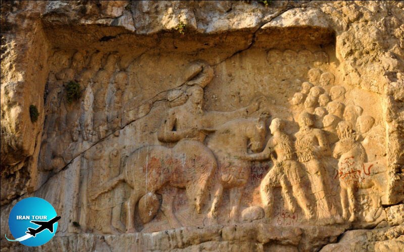 |
- Darab Bas-relief
The victory bas-relief at Darab is among the earliest and most controversial of the Sasanid carvings. There is no universally accepted interpretation of this scene, though the dates suggested by different hypotheses vary by only some thirty years, from the late 230s to the 260s. The bas-relief shows the figure of a Sasanid emperor mounted on a horse in the middle of the carving. Heavy growth of long, curly hair frames his manly face, which is seen in three-quarter view. He has a mustache and a long beard which is held by a ring. His headgear consists of a diadem and a tall turban, to which bands of crimped ribbon are attached. The king wears a long, draping shirt, with its flaps falling freely over the horse's back. A cape is fastened with round buttons over his chest, and its folds float in the air behind him. The king wears trousers made of the same light fabric as his shirt. The trousers are decorated with ribbons at the ankles, and the ends of the ribbons fall to the ground. The monarch wears a necklace of large pearls, while bracelets adorn his wrists.
The horse is very large and stands sturdily on all four feet. The animal is ostentatiously bedecked. and it appears that its harness was once dotted with pearls; these, of course, have disappeared. A huge tassel hangs from the saddle; such tassels are still used by Bedouin Arabs as fly whisks. The horse tramples the figure of a defeated enemy, prostrate under its hooves. The figure wears a beribboned wreath. Two figures are portrayed standing in front of the king. One of them bends in respect before the monarch, and the king touches his head with his left hand in a gesture of royal condescension and mercy. The man is definitely not Iranian. He is middle-aged, has short hair, and his head is crowned with a wreath, to which a short ribbon is attached. His outer cape is fastened on his shoulder. His right hand is raised.
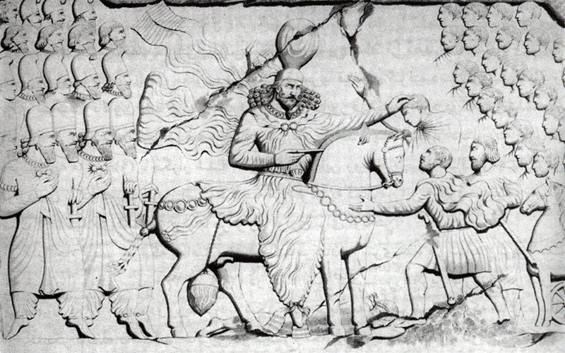 |
This person is half-hidden by a rather short figure of another man, who has a short beard and a diadem or a fillet across his forehead. This man wears a short shirt or tunic, and over it, a cape. Fastened to his belt is a sword with a bird-shaped handle. With hands clasped together, he touches the horse's bridle, as if pleading for mercy. To the right of the man stands an Iranian nobleman. Behind the monarch, on the left, are shown four rows of Sasanid courtiers. The personages in the first rows may be princes or members of the high-ranking nobility. Two of these persons used to have flowers in their bent right hands; this motif may have been borrowed from Persepolis. The men in the upper rows may be military men; the first person in the third row holds a sword, which may have been prepared as a gift for the person whose head the king is touching benevolently.
 |
Carved in the right corner of the scene, and giving balance to its composition, is another group, this time of twenty-two Romans with short beards and hair. All of these are shown in the profile. In the lower right-hand section is a horse pulling a chariot. This animal is much smaller than the Shapurs mount. Its harness also differs strikingly from that of the monarch horse. The chariot, though there was no space to show it completely, was certainly meant as war booty. Most authorities believe that the crown Shapur is wearing in the bas-relief is that of his father, which would indicate that the scene dates from the period of Shapur attribution of the engraving to an early date. However, the presence of three defeated Romans in this scene is difficult to explain in the light of the known historical events. The three Roman emperors defeated by Shapur were Gordian III, Philip the Arabian, and Valerian. Gordian is usually shown trampled under the hooves of the king's horse, Philip is shown kneeling, while Valerian is portrayed standing by the monarch's side - a pose resembling the one represented at Darab. However, Shapur's victory over his Roman adversaries occurred at a much later date: Gordian was slain in battle in 243, Philip sued for peace in 244, and Valerian was taken prisoner in 260. Even if we believe what some suggest that only the first two of these emperors are portrayed here, while instead of Valerian, Cyriades (the citizen of Antioch who helped Shapur to capture the city and was later appointed the local ruler) is shown, we still go beyond the date of 242, when Shapur officially put on his famous dentilled crown. Thus, we find no explanation for why he is carved here wearing his father's crown.
Some scholars have suggested that the relief depicts other, little-known victories of Ardashir, or even of some symbolic Sasanid monarch, but few persuasive arguments have been produced on behalf of these theories. The bas-relief is carved in a manmade recess in the rock, 8.4 by 6 m. The sculpture has been damaged by a cliff fracture, and by nomads who used the figures as targets for shooting practice. The carving used to soar above a beautiful spring of water, but the spring has dried up. Two very small and much-eroded bas-reliefs are carved beneath the main scene. One of them is believed to show Shapurdokhtak, the consort of Narses, and the other, a warrior stabbing a rampant lion.
 |
-Stone Mosque
About 6 km from Darab, one of the most interesting structures in the region is carved out of the heart of the mountain. The rock-hewn architecture was widespread in Iran, particularly during periods of trouble and unrest, and ranged from single structures to entire complexes of buildings. Still, because of the astounding precision of its layout, the Stone Mosque in Darab stands out from among them all. Most scholars agree that the structure probably belongs to the Sasanid period, but was converted into a mosque during Islamic rule.
The mosque has a cruciform plan, with the longest aisle leading from the entrance and stretching from southeast to northwest; from the doorway to the rear wall, this aisle is 20 m long. The other aisle, crossing it at a right angle, is about 18 m long. Where the aisles crossed at the center of the mosque, a square pool about 3 m long on a side is carved on the floor. Today the pool is filled up with stone, and its exact depth is unknown. Straight above the pool and of exactly the same dimensions, a light vent was hewn out of the ceiling. It appears that the construction of the mosque was begun with this opening, and that first a square well was dug out in the mountain as deep as the original bottom of the pool. Then alcoves were carved out on every side of the well until an almost perfect cross was achieved. A vestibule about 3m long and 10 m wide, and a doorway about 2 m wide and 5 m high, was added to complete the structure. At a later date, perhaps already during the Islamic period, the cruciform core was surrounded by corridors about 1 m wide, interrupted only on the side where a mihrab was incised. These corridors may have been curtained off to accommodate women, who prayed separately from the men, or it may have been the area for the common people, to separate them from the nobility, who gathered in the alcoves. The building has two Kufic inscriptions, one engraved on the mihrab and the other above the door that links the vestibule to the sanctuary; one inscription has a date of 1254. Among badly eroded scriptures, the scholars managed to discern the name of Saad ibn Zangi.
Adjacent to the mosque is a chamber, to which one ascends by a flight of three steps. The chamber measures 8 m long, 3 m wide, and 2 m high. It may have served as a residence for a custodian of the mosque, or as a warehouse for religious paraphernalia. It is also possible that at some time during the Islamic period, the main structure housed a Khaneqah, while the chamber was a place of seclusion for dervishes. A water supply system in the vicinity also seems to be Sasanid in date. It is carved out of the living rock, and a long canal laid with stone slabs and bound with mortar seems to have guided water from the Rudbar River to a water mill.
 |
-Azarju Fire Temple
What looks today more like a heap of rubble, used to be one of the important fire temples during the Sasanid rule. Located about 12 km north of Darab, the building stands on a natural platform about 3 m high and is ascended by a short staircase. The structure itself is roughly 15-m square and is about 6 m high. It was undoubtedly crowned by a dome, which may have been about 3 m high; no traces of this, however, currently remain. The temple is built of stone and mortar and seems to have been coated with a layer of plaster.
The site is very arresting, enclosed on all sites by spectacular mountains. Beside the temple bubble two springs, called locally Oglan-Ghez (“The Son and the Daughter"); their water is collected in a natural pond. An ancient tree casts its imposing shadow over the pond. One cannot help marveling at what extraordinary sites the Sasanid kings chose for their monuments.
-Korsia Fire Temples
Even though many Sasanid monuments have disappeared, the area around Darab is still dotted with Sasanid structures. Two Chahartags, built of rubble stone, and mortar, stand near the village of Korsia in the vicinity of Darab. One of these has survived up to the squinch level; only a stone base has remained of the other. Chahar-Taqs were essential to any Sasanid settlement, and their great number in the region testifies to their importance under the Sasanians.
-Palace of Kiumars
No historical or archaeological information is available about this structure, half of which lies in ruins, but its local name "the Palace of Kiumars" bears evidence at least in local tradition, to its great antiquity. Although the building features many characteristics of Sasanid architecture, it nevertheless seems to be later in date and belongs perhaps to the early Islamic period. It consists of three halls formerly crowned with domes, all of which have collapsed completely. The domes were supported by rectangular piers, embellished with half-embedded, slender columns, covered perhaps with a layer of stucco moldings. The central area is enclosed around its perimeter by arched passages, which on the outside are divided into three distinctive sections; large parts of the passageway have also disappeared. There are the remains of a corner staircase, which probab] led to the rooftop.
-Mir Tork Fire Temple
Mir Tork (the name's origin is unknown) is one of the numerous Sasanid sanctuaries that have survived around Darab. This square structure has a door on one side, while the other three sides are pierced with rectangular openings. Additional light was provided from a vent on top of the dome; this vent may have been closed with a lid in colder seasons. Built of rubble stone and mortar, the building is very plain on the exterior. Inside, however, its walls are decorated with round, shallow niches. The area around the Mir-Tork Temple seems to have been enclosed by a wall.
-Fadami Falls
The Fadami Gorge is a unique natural site, with seven waterfalls streaming from its cliffs. It is particularly surprising because it is located on the edge of the vast desert starting at close proximity and stretching as far as the Kerman region. Curiously, some of the waterfalls of the Fadami Gorge have sweet, and salty water. Sad to say, the gorge can be reached only during the summertime, and even then the trek is very difficult. During the very hot, arid summers, some of the waterfalls dry out at times.
-Chak-Chak Gorge
When the visitor is obliged to make a very exhausting trek, albeit a short one, s/he has the right to expect the trek to have been really worthwhile. Fortunately, the Chak-Chak Gorge well merits the effort. This is a remarkably beautiful natural site, with a savory scent of history. One of the cliff faces enclosing the ravine has been hand-polished to such an extent that the entire gorge was mirrored in it. For this reason, the site is also known as Qasr-e Aineh (“The Mirror Palace”). The polishing was done not only for a curious artistic effect but was, as well, a deliberate security measure: by means of the mirror wall, sentinels at a watchtower soaring above the ravine could view the rear of the site, in case enemies tried to enter there. Some also think that the cliff was polished to make room for a Sasanid carving which was never executed.
In the cliff to the left of the polished surface is a low, wide grotto, from the vaults of which water oozes and drips into a stone pool that was carved in situ. The sound of this dripping (onomatopoeic chak-chak in Persian) gave the site its popular name. On the opposite bank of the river that flows through the ravine stand two Sasanid structures. One of these, at the front, is a square building surmounted by a dome. One of its walls has been destroyed, but the dome and the other three are fairly well-preserved. The walls, built of stone rubble and mortar, are provided on the inner side with evenly-spaced shallow niches, three in each wall. The fourth wall, today in ruins, must have had a door. In the middle of a low dome, whose shallowness is emphasized by high walls, is a vent for light and air. Beneath it on the floor are visible the remains of a hearth, where a fire was kept burning. Behind the fire, the temple stands a typical Chahar-Taq, composed of a square base with round arches, and a dome. Part of the dome has crumbled, but its high drum, pierced with small openings around the perimeter, has remained. The entire site must have been enclosed by a rampart, but only scattered stones of this have survived.
- Details
- Category: Museums of Shiraz